WXTide32 - a free Windows tide and current prediction program.
- Predicts tides from 1970 through 2037.
- More than 9,500 stations worldwide
(list) with 160 in England, Ireland and Scotland.
- More than 300 tidal current stations, all in North America.
- User station manager to easily add custom tide and current subordinate stations.
- Text outputs: daily tide list, monthly calendar, incremental tide.
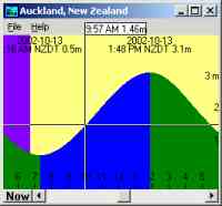
- Graphic modes: tide clock, realtime graph, scrolling graph, overview.
- Each graphic mode has separate display options and window settings.
- Supports legacy ASCII text and new binary TCD harmonic constituent files.
- Supports user-installed World Vector Shoreline (WVS) map files.
- Can play user-installed ship's bells sound files on the half hour.
- Designed for interactive use but can also be used from other programs.
- Generates BMP graphics and text tide CSV spreadsheet files.
- Worldwide timezones, solar/lunar events, recent stations, realtime tide state icon.
- Low resource usage typically 4 MB disk, 5 MB RAM active, 1 MB as icon.
- Tested with auto-install on Windows 9x, NT4, 2000, ME, XP, 7.
- Tested with manual install only for 8.0, 8.1 and 10. (Win10 cannot read help file)
- Self-contained, nothing else needed.
- Context sensitive help and all "C" source code included (Not Windows 10).
Do not rely on the output of this program for decisions that can result in
harm to any person or property. There is no way to provide certified data on
a zero budget so if you need guaranteed results then WXTide32 is not for you.
This is free software; you can redistribute it and modify it under the terms
of the GNU
General Public License
as published by the Free Software Foundation; either version 2 of the
License, or at your option any later version. While the software is free,
it is protected under copyright and no rights are given for others to profit
from my efforts.
WXTide32 is based on the UNIX program
XTide
version 1.6.2 written by Dave Flater.
News
April 2017: Updated to new hosting.
February 2010: Finally restored the WXTide32 forums using
freeforums.org. I have had little time to answer email to this will serve
as a user-to-user forum.
February 2007: Released version 4.7 to implement new U.S. timezones
and a couple bug fixes
(see change list).
July 2006: It has come to our attention that there is at least one person
selling WXTide32 on eBay. Selling WXTide32 is in direct violation of the GNU
license under which the software is released and I have notified eBay of the
violation.
June 2006: Release version 4.6 adds mostly bug fixes.
May 2006:We have added the ability to download files directly from
this web site. See the
download page.
May 2006:We are on our new web host and busy making sure most of the
sites are still working. AffordableHost, our previous (and never again)
provider, just could not keep the server they put us on going for more than a
few hours at a time. Not only were we unable to send email for the past 3
weeks, but the web sites were up and down like the tides. Being able to
respond to email will be a relief. We thank you for your patience.
Errata and reported anomalies
- The reference station Norwegian Bay, W. Coast, Australia has been
found to be totally inaccurate. To get correct tides for that location
generate a User Station with Carnarvon, Australia as the reference station
and use time offsets of -8 minutes to both the low and high tide times.
- Windows 8 broke the install program. Use manual install instead.
- Windows 10 broke the help system.
WXTide32 revision history
Version 4.7 2007/2/25
- Changed: Implemented new U.S. timezones.
- Changed: Multiple pop-ups when config file not writable. Now only 2 show.
- Fixed: Tooltray icon showed incorrect time to next tide when using mark level.
More release history here
Download
WXTide32 is distributed as a single ZIP file with a small setup program for
automatic install on older systems and as a preset program for
manual install on modern systems.
Also see the optional download of
World Vector Shoreline map files and
ship's bells sound files below.
Auto Install up to Windows 7
Download the latest auto-install version
wxtide47.zip
(1,599,337 bytes, February 25, 2007)
An automatic install using WinZip or
other commercial unzip program is the easiest method of install but unfortunately,
only works for older systems. Many unzip programs will
offer an Install option using the installer included in the zip file. This
installer will generate a program folder in the apps folder on the system
drive then make start menu items for the program and help file. The install
folder is usually "C:\Program Files\WXTide32\" but may vary.
Manual Install for any version
Download the latest manual install version
wxtide47m.zip
(1,586,329 bytes, February 25, 2007)
- Create an empty folder for the program, usually
"C:\Program Files\WXTide32\" but any folder will do.
- Unzip all files into that new empty folder.
- Find "WXTide32.exe" in the new folder and right click drag it to
your desktop to make a shortcut for the program.
Uninstall
If the program was installed using the default installer, you can uninstall
from the Control Panel->Add/Remove Programs list.
- or -
WXTide32 does not modify any files outside it's install folder so you can
safely just delete all files in that folder and the folder itself.
Optional World Vector Shoreline (WVS) data
The program can use World Vector Shoreline (WVS) map data in place
of the map picture included in the program. This map is displayed from
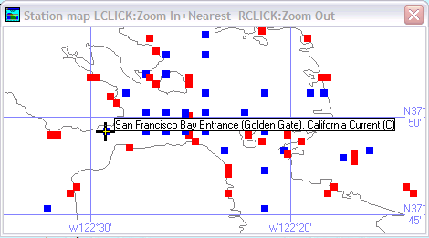
the Station Locator window when the Map option is checked. WVS data is
public domain high detail gridded vector representation of the coastal
shorelines of the world.
While support for the WVS files is in the program, the WVS map files
themselves are not. The WVS files used with this and the XTide program
are the same as those from those distributed on the National Geophysical
Data Center (NGDC) Global Relief Data CD-ROM.
As of May 2017, sources of WVS map files compatible with WXTide32 were:
To install the files, just unzip them into the WXTide32 program folder;
they will be automatically detected when the program is next started. Not
all files are absolutely needed; the program will find the best available
match for any given zoom factor. The file wvs43.dat is essential for
speed when drawing the entire world. Other files give increasing detail and
allow higher zoom factors. We found that using only wvs43.dat and
wvs250k.dat gives great detail with no speed impact.
The full set of WVS map data consists of the following files:
wvsfull.dat - full resolution - 25,313,280 bytes
wvs250k.dat - 1:250,000       - 18,232,320 bytes
wvs1.dat    - 1:1,000,000     - 4,896,768 bytes
wvs3.dat    - 1:3,000,000     - 5,121,024 bytes
wvs12.dat   - 1:12,000,000    - 2,933,760 bytes
wvs43.dat   - 1:43,000,000    - 2,233,344 bytes
Optional ship's bells sound files (Not Windows 10)
The program has the ability to play Ship's bells sound files on the
half-hour. The general population may not be interested in this option, but
for us sailors, it is comforting to hear the bells while far away from the
sea. Ship's bells count the number of hours and half hours on a 4-hour
cycle. The cycle starts with one bell at 12:30 (or 4:30, or 8:30), followed
by 2 bells at 1:00, 3 bells at 1:30 and so on until 8 bells at 4:00. Then
the cycle repeats for the 4:30 to 8:00 watch, then finally 8:30 to 12:00.
Note: The dog watch sequence from 4pm to 8pm is not supported (yet).
To use this feature you must have 8 sound files named 1bells.wav, 2bells.wav
through 8bells.wav where the name gives the number of bells in that sound file.
A rich sounding set of files, size 1163kb, submitted by Stuart H. is
wxtide32_bells.zip.
Once the file has been downloaded, unzip them into the WXTide32 program folder.
The next time the program is started, you will see a new main menu item named
Play ship bells.
FAQ
Last updated 03/25/2005.
Try looking here first for answers to your questions. I have included the
most often asked ones and everything here is now also included in the help
file.
What does WXTide32 stand for and how do you pronouce it?
Why is WXTide32 showing me the wrong time?
What happened to the England (and Ireland and Scotland) tide data?
How do I set up a custom subordinate station?
How do I set up a program shortcut for a custom station?
Can I set up a custom reference station?
Why do the currents for some stations show units as Knots^2 or Kt^2?
Is this Dave Flater's program or yours?
Why don't you charge for the program?
Did you know the Galapagos are owned by Ecuador?
Is there any other information about the UNIX version XTide?
Is there a version for the Mac?
Why does WXTide32 keep asking if I want to save options when I exit?
What does WXTide32 stand for and how do you pronouce it?
The "W" is for Windows, "Xtide" is the name of the UNIX
program it is based on, and 32 stands for 32 bit Windows
versions only. Back when I began programming WXTide32, 16-bit Windows and DOS
were still common so the 32 was supposed to indicate Windows 95/NT+. As for
how to say WXTide32, I say it like Wicks - Tide - 32, all run together.
Why is WXTide32 showing me the wrong time?
WXTide32 uses the time maintained by your PC for all tide computations. To
work properly, your computer's time and date and timezone must be set
correctly. To check the timezone, right click on the clock in the tool tray
(usually in the bottom right of your screen), select Adjust Date/Time, then
select the Timezone tab.
What happened to the England (and Ireland and Scotland) tide data?
With the release of version 4.0, there are now harmonic constituent data for
44 stations in U.K., Ireland and Scotland. While not as extensive as was
previously available, at least there are now some ports for that area. For
what happened to the prior data set please read the following:
In 2001, I was notified by the United Kingdom Hydrographic Office (UKHO) that
the Crown claimed copyright ownership of all tidal products for Great
Britain, Ireland and Scotland. My options were to stop distributing tidal
data for those areas or purchase a license (with a recurring fee) for use of
the official UKHO data. WXTide32 has never been a commercial endeavor so I
declined their offer of buying a license. It appears that when the
International Hydrographic Office (IHO) disbanded in 1999, tidal data
ownership reverted to individual countries and the blanket approval IHO gave
for non-commercial use of world-wide tidal data was rescinded. Since Great
Britain has now claimed copyright ownership, other countries may follow suit.
This means that only tidal data for countries that have explicitly released
their data to public domain may be used free of risk of copyright
infringement. Data for the U.S. is not a problem. That data was gathered
using public (taxpayer) funds so no copyright is or can be attached to NOS or
NOA tidal data. Likewise, tidal data gathered by the U.S. in other countries
and published by them is free of copyright restrictions. But that still
leaves lots of world and the database distributed with WXTide32 starting with
version 2.7 shows that new greatly reduced area of coverage.
How do I set up a custom subordinate station?
To set up a custom subordinate station, you must have the name of a reference
station and a set of adjustment values that define the tide differences at
the subordinate station. Reference stations are shown in the station location
list with a (T) or (C) at the end of the name. To this reference station, a
set of time and level offset adjustments are applied. With this information,
you can set up a custom station by doing the following:
1: Select the reference station from the location menu.
2: Select "Custom Station" from the main menu and fill in the blanks.
3: Save a station configuration file with a name that describes that station.
Details on what the Custom Station menu does
If you insist on doing it yourself, here are the variables used in
defining a custom subordinate station:
-location "Name of reference station"
-htoff Sets the high tide offset (+- feet) and/or ratio (*x.x).
-ltoff Sets the low tide offset (+- feet) and/or ratio (*x.x).
-httoff Sets the high tide time offset (+-HH:MM).
-lttoff Sets the low tide time offset (+-HH:MM).
-custname Sets the name for the custom station.
For example, the command line switches for Gandy Bridge Marina might be:
-location "St. Petersburg, Florida" -htoff *1.3 -ltoff *1.1 -httoff +1:32
-lttoff +1:34 -custname "Gandy Bridge Marina"
See the next topic for how these settings can be incorporated into a single
click shortcut.
How do I set up a program shortcut for a custom station?
1. Generate a new desktop shortcut by finding WXTide32.exe in Explorer
then dragging the file onto the desktop. Change the name of the new shortcut
to something meaningful for the station you are about to set up.
2. Right click on the shortcut and select "Properties" from the pop-up list.
3. Click on the Shortcut tab.
4. The line marked "Target:" will be highlighted.
5. On this line, after "...\WXTide32.exe" add any custom settings you want
set when you double click that shortcut. For example, one of my shortcut
command lines reads:
C:\Program Files\WXTide32\WXTide32.exe -location "Safety Harbor" -keepindex
-nowarn -hairy -skinny
or, instead of command line switches, just enter the name of a configuration
file that has the options you want, either one you made or one you saved from
within the program.
C:\Program Files\WXTide32\WXTide32.exe "my config file.wxt"
6. Click "OK" to save the settings.
Can I set up a custom reference station?
Sorry, but you really can't do that.
Why do the currents for some stations show units as Knots^2 or Kt^2?
Knots squared is the result in computing hydraulic currents. Note that only
the current is squared, not the datum, so you can't just take the square root
to get the actual current speed in knots. WXTide32 has an option to
automatically convert knots^2 to knots.
Is this Dave Flater's program or yours?
WXTide32 is a windows port of Dave Flater's UNIX program XTide version
1.6.2. Whereas Dave has spent years making XTide work the way he wanted, I
only have a few thousand hours into WXTide32 (groan :). My most satisfying
contribution has been the station location logic with the clickable and
zooming station locator map. That is in addition to all of the work needed to
convert the base version of XTide to run under Windows 9x/NT. I took on this
project because my wife and I are sailing cruisers and I didn't want to pay
$1000 for worldwide tidal data for the Windows tide programs that are
available now. While the DOS tide program we used while cruising (the
excellent Tides 2.4 by Hans Pieper) worked fine, I wanted a more visual and
hopefully more friendly interface, not to mention an extremely attractive
price.
Why don't you charge for the program?
Since the source code for XTide has been made available for free, I have
decided to continue that tradition. Besides, I figured that not all cruisers
or other outdoors people may be able to spend the money for one of the fancy
commercial packages. None of this means that I would return money if someone
wanted to send us some, however :)
Did you know the Galapagos are owned by Ecuador?
Yes, I knew that but decided to make all detached islands autonomous
rather than trying to determine ownership for all islands. In fact, I wanted
to just make "North Cold" and "South Cold" regions for all those areas that
were outside of about 60 degrees but my wife vetoed that since she felt some
people who actually like cold weather might be offended.
Is there any other information about the UNIX version XTide?
Sure, try Dave Flater's
XTide web site. He
has totally rewritten XTide in C++ since the base version I used for
WXTide32. His new version is packed with new features and works great on UNIX
web servers in case you want that function.
Is there a version for the Mac?
No, and I don't plan on doing one.
Why does WXTide32 keep asking if I want to save options when I exit?
Set the "Auto-save" option on exit" option on the Preferences menu and
WXTide32 will always start the next session the way it was when last run.